| Sign In | Join Free | My ecer.jp |
|
| Sign In | Join Free | My ecer.jp |
|
| Categories | RTK GNSS Receiver |
|---|---|
| Brand Name: | Kolida |
| Model Number: | K5 plus |
| Certification: | CE |
| Place of Origin: | China |
| MOQ: | 1 set |
| Price: | Negotiable |
| Payment Terms: | L/C, D/A, D/P, T/T, Western Union, MoneyGram |
| Supply Ability: | 100 set per month |
| Delivery Time: | 3 days |
| Packaging Details: | Carton |
| product name: | RTK GNSS Receiver |
| channel: | 220 |
| Water/Dustproof: | IP67 |
| With external radio: | 8-20km |
| Network RTK: | 15 mm + 0.5 ppm RMS |
| Internal momery: | 1.02kg |
| Company Info. |
| Shanghai Hengyide Electronic Technology Co.,Ltd Ltd. |
| Verified Supplier |
| View Contact Details |
| Product List |
1 set packed in 3 cartons:
50*40*23cm (8kg)
50*40*23cm(8kg)
150*20*20cm(5kg)
Key Features:
Specification:
| SPECIFICATIONS | |
| Surveying Performance | |
| Channel | 220 Channels |
| Signal Tracking | BDS B1, B2, B3, |
| GPS L1C/A, L1C, L2C, L2E, L5 | |
| GLONASS L1C/A, L1P, L2C/A,L2P, L3 | |
| SBAS L1C/A, L5( Just for the satellites supporting L5 ) | |
| Galileo GIOVE-A, GIOVE-B, E1, E5A, E5B | |
| QZSS,WAAS, MSAS, EGNOS, GAGAN, SBAS | |
| GNSS Feature | Positioning output rate: 1HZ~50HZ |
| Initialization time : <10s | |
| Initialization reliability: >99.99% | |
| Positioning Precision | |
| Code Differential GNSS Positioning | Horizontal: 0.25 m + 1 ppm RMS |
| Vertical: 0.50 m + 1 ppm RMS | |
| SBAS positioning accuracy: typically<5m 3DRMS | |
| Static GNSS Surveying | Horizontal: 2.5 mm + 0.5 ppm RMS |
| Vertical: 5 mm + 0.5 ppm RMS | |
| Real-Time Kinematic Surveying (Baseline<30km) | Horizontal: 8 mm + 1 ppm RMS |
| Vertical: 15 mm + 1 ppm RMS | |
| Horizontal: 8 mm + 0.5 ppm RMS | |
| Network RTK | Vertical: 15 mm + 0.5 ppm RMS |
| RTK initialization time: 2~8s | |
| Physical | |
| Dimension | 13.4cm × 11.8cm |
| Weigh | 1.02Kg(includiing installed battery) |
| Material | Magnesium aluminum alloy shell |
| Environmental | |
| Operating | -45℃~+60℃ |
| Storage | -55℃~+85℃ |
| Humidity | Non-condensing |
| Waterproof/Dustproof | IP67 standard,protected from long time immersion to depth of 1m |
| IP67 standard,fully protected against blowing dust | |
| Shock and Vibration | Not operating: Withstand 2 meters pole drop onto the cement ground naturally |
| operating : Withstand 40G 10milliseconds sawtooth wave impact test | |
| Electrical | |
| Power Consumption | 2W |
| Battery | Rechargeable,removeable Lithium-ion battery |
| Battery Life | Single battery: 7h (static mode) |
| 5h (internal UHF base mode) | |
| 6h (rover mode) | |
| Communications and Data Storage | |
| I/O Port | 5PIN LEMO external power port+RS232 |
| 7PIN LEMO RS232 + USB | |
| 1 network/radio data link antenna port | |
| SIM card slot | |
| Wireless Modem | Integrated internal radio receiver and transmitter 0.5W/2W |
| External radio transmitter 5W/25W | |
| Working frequency | 410-470MHz |
| Communications Protocol | Trim Talk450s,TrimMark3,PCC EOT,KOLIDA |
| Cellular Moblie Network | WCDMA3.5G network communication module,GPRS/EDGE compatible, |
| CDMA2000/EVDO3G optional | |
| Double Module Bluetooth | BLEBluetooth 4.0 standard,support for android,ios cellphone connection |
| Bluetooth 2.1 + EDR standard | |
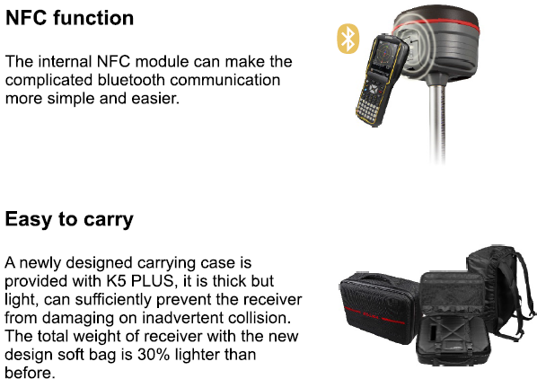
| NFC Communication (Optional) | Realizing close range (shorter than 10cm)automatic pair between K5 PLUS and controller |
| (controller equipped NFC wireless communication module needed) | |
| Data storage/Transmission | 4GB internal storage, more than 3 year raw observation data (1.4M/day) |
| base on recording from 14 satelites Plug and play more of USB data transmission | |
| Data Format | Differential data format: CMR+,CMR×,RTCM 2.1,RTCM 2.3,RTCM 3.0, RTCM3.1,RTCM3.2 |
| GPS output data format: NMEA0183,PJK plane coordinates,binery code | |
| Network model support: VRS,FKP,MAC,supporting NTRIP protocol | |
| Inertial Sensing System(Optional) | |
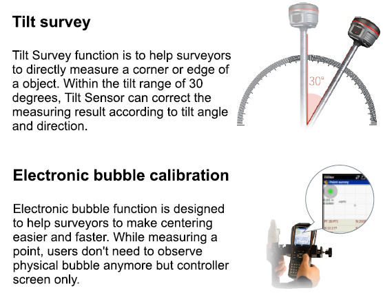
| Tilt Survey | Built-in tilt compensator, correcting coordinates automaticlly according to the tilt direction and angle of the centering rod |
| Electornic Bubble | Conteroller software display electronic bubble, checking leveling status of the centering rod real time |
| User Interaction | |
| Buttons | One-button operation, Visual operation, convenient and efficient |

|
